9th St. Bridge
Looking at the David Lawrence Convention Center in
downtown from the 9th St. Bridge. I've
visited convention centers all over the
place, and know the exterior design of the DLCC
on the river side is gorgeous.
|
|
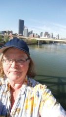
9th St. Bridge
Selfie from the 9th St. Bridge, looking at the 7th St. Bridge, 6th St. Bridge and downtown.
|
|
|
7th St. Bridge
There was also a 5k and a fun run on Saturday. Here are some of these runners coming across the 7th. St. Bridge
|
|
Penn Ave.
Selfie from the 7th St. Bridge looking back towards the
Alcoa Building and 9th St. Bridge towards
the North Side. I'd walked about 4.75
miles at this point. I walked that distance many times and still felt good to go.
|
|
|
North Side
Pittsburgh Traditional Academy on the North Side
|
|
North Side
About 5.6 miles into the walk, I went by the entry to the North Side park where the National Aviary
is. I got
a little lost at this point, but wound up
on a parallel street and found Western
Ave.
A little over 2 hours and 6 miles into the walk, I decided
to take a break at the Western Ave
McDonald's (also, I was about to
walk nearly 3 miles in an area without
places to stop (though I turned out to be
wrong about that)). And then I headed off
to the West End Bridge. I failed to get a
decent photo of the bridge from a distance
due to the odd location of the walkway.
|
|
|
West End Bridge
Selfie on the West End Bridge, looking west along the
Ohio River. While the West End Bridge is
on the western end of Pittsburgh, it's also
the very first bridge over the Ohio, at its
far eastern end.
|
|
West End Bridge
Point State Park Fountain and downtown Pittsburgh. Ohio River is in the foreground, the Monongahela River is on the right (with the Ft. Pitt Bridge going over it) and the Allegheny River on the left (with the Ft. Pitt Bridge going over it).
|
|
|
West End
Entry into the West End. The roads in this area were
ripped up and rebuilt in the last few years. It is usually
much easier to drive in the West End
now than it was before about 2012.
|
|
West End
Steuben St. and Alexander St. were about the only hills
on the half-marathon, which is kind of
amazing given how hilly Pittsburgh is. But
that makes the half-marathon a more doable
route for more people, at least for me. I
find steep hills are tough on my knees, but
I regularly walk a fairly steep hill in my
neighborhood.
|
|
|
West End
Main St. of the West End is becoming more upscale (but I
really miss one of its first upscale stores
- the original Vanilla Pastry Studio). I
had forgotten that there were places I
could have stopped on that part of the route.
|
|
West Carson St.
While most of the half-marathon routes has sidewalks,
nearly a quarter of a mile between Main
St. and West Carson St. has no sidewalk. I
walked pretty quickly down this hill, then
got across West Carson to the one sidewalk as soon as it was safe to do so.
|
|
|
West Carson St.
View of the Fort Pitt Bridge from East Carson St. I'd walked about 8 miles (20,000 steps) in under 4 hours. Well, I never said I was fast.
|
|
Station Square Parking Lot
At about 8½ miles, I realized I was feeling sunburned.
I took a slight detour, but one that was
parallel to the official route - I walked into the Station Square parking lot and sat in the shade. Got a good shot of Heinz Field and the Carnegie Science Center across the Ohio River.
|
|
|
Station Square Parking Lot
Another shot of the Point State Park Fountain, this one
a little closer to Station Square.
Pittsburgh had a bad reputation when I
considered going there for college in 1975,
but I liked it very much from the first
time I visited almost exactly 40 years
ago. The downtown had a major rebuild in
the '50s and early '60s and some minor
tweaks since then. It's a wonderful place
to live.
|
|
Station Square
Wandered through Station Square, found a place that sold
sunscreen (!), used the bathroom, got a
soda. Station Square has been through many
incarnations over the years, starting off
as a train depot in the late 19th century
and later being converted into a
shopping/restaurant area in 1980. It's
almost the exact age of Leslie, and is the
spot where we bought her her first balloon
(or bought it for her stroller) around
Christmas 1980.
|
|
|
East Carson St.
The mile or so between Station Square and the more commercial section of the South Side is kind of...well, unpleasant. But, at this point I'd walked over 9 miles, was refreshed from my break and I knew I could make it the rest of the way.
|
|
East Carson St.
One of the many Orthodox churches in the Pittsburgh
area. I realized my phone was running out
of juice, which was too bad because the
South Side has many interesting spots to photograph. So I turned off my phone.
|
|
|
Birmingham Bridge
The last obligatory bridge selfie! On the Birmingham
Bridge looking back along the Monongahela
River towards downtown Pittsburgh. I'm looking quite opimistic as I was down to my last 2 miles or so and it was mostly downhill all the way from there. Sadly, the sidewalks in most of the Hill District are not in very good shape. Forbes Ave had recently been resurfaced, so I hope the next step is better sidewalks.
|
|
|
|
|
|
 |
|
|
|
|
"Near the Finish Line" - Actually Forbes and Smithfield
I made my single-biggest route-screw-up by staying on
Forbes until I got to downtown. I was
supposed to shift to the Boulevard of the
Allies, which made much more sense
given the construction on lower Forbes.
But, at that point, rather than walk over
to the Boulevard to do that last block, I
knew Jim was waiting for me a half mile in
the opposite direction so I went to meet
Jim.
So I declared victory. That was my longest walk at one
time, though I admit to a few stops along
the way, I walked the 13 miles over 6 hours
(or, a little under 5 hours of actual
walking). Total for Saturday: 15 miles of
walking or about 39,000 steps. Part of
the reason I did this was because we fat people fall into a rut. True, I can't run, but I can walk. How many people out there have walked a half marathon? It's the sort of thing you can do at almost any size. I also did it because I find Pittsburgh a great place to photograph, and will have to do a walk up and down the South Side one ay this fall with my better camera and charged batteries.
|
|
|